We had an earthquake in LA today. Five-four. No big deal, but it got my attention, and got me to thinking about what earthquakes have to tell us about the age of the earth.
The modern scientific explanation of what causes earthquakes is that what we think of as solid ground is really just a thin (relatively speaking) layer of frozen rock floating on an ocean of molten magma that makes up the earth's mantle. New crust is formed at mid-ocean ridges, floats along for a while, and is ultimately re-cycled into the mantle in subduction zones. Where the plates of land mass butt up against each other there is friction, and so as the plates move past each other they don't move smoothly, but in little fits and starts that we feel as earthquakes.
Plate tectonic theory used to be considered patently absurd, but is nowadays as well established a scientific theory as you could hope to find. It explains not only earthquakes, but a host of other phenomena including the formation of mountain ranges and why fossils of tropical plants and animals can be found in the arctic. Thanks to modern GPS we can actually measure the motion of the continental plates with mind boggling accuracy.
Which brings me to Hawaii.
The eight major islands of the Hawaiian group (Hawaii, Maui, Molokai, Lanai, Kahoolawe, Oahu, Kauai and Lanai) are actually just the beginning of an enormously long chain of islands, islets, atolls and seamounts extending over 1500 miles of the Pacific ocean in an almost perfectly straight line. How did they get there? Well, on the southeastern extreme of the Hawaiian chain is the Big Island of Hawaii, and on the southeastern coast of the Big Island is Kilauea, he world's most active volcano. Kilauea has been spewing hot lava into the sea more or less continuously for the last twenty five years (and off and on for thousands of years before that). The lava from Kilauea flows down into the sea where it hardens into rock and becomes new land. The current eruption has created almost 600 acres of new land in the last twenty five years.
Hawaii is growing.
The total area of the Big Island is about 2.6 million acres. If Kilauea keeps building new land at the current rate the size of the island will double in about 4300 years. The historic accretion of the island is being chronicled in great detail. You can actually go to Volcano Nation Park and see it happening before your very eyes. They even have signs telling you which lava flows happened when. And for those who don't have time to actually go there, there are handy dandy maps.
What about all the other islands in the Hawaiian chain? None of them have active volcanoes. The closest thing to an active volcano on the other islands is Haleakala on the southeast lobe of the island of Maui, the next island up the chain from the Big Island. Haleakala is a dormant volcano that last erupted in 1790 [UPDATE: turns out that it was probably closer to 1500]. The lava flowed into the sea, creating a new peninsula that is today the southern boundary of La Perouse Bay. But since then no new land has formed on Maui, and the island has begun to erode away.
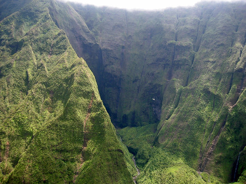
As you travel northwest along the island chain a striking pattern emerges: all of the islands are made of the same kind of volcanic material, but the further you get from the Big Island the smaller and more eroded the islands become. On the Big Island you can see the lava coming out of the ground. On Maui you can see the lava flow of 1790 [UPDATE: new evidence indicates that the flow is a bit older, dating back to around 1500 or so] -- it looks like a barren river of rock. But on Lanai, Molokai and Oahu there is no fresh lava at all, but there are still recognizable volcanic features, like Diamond Head. By the time you get to Kauai you have to look very closely to find the clues that it was once a volcano. You can still see the crater that used to be the volcano, but it has mostly eroded away.
Out past Kauai the last "real" island is Niihau, which is privately owned and closed to the public. There is no geomorphic evidence of volcanic activity on Niihau, but we know that it was formed by the same volcanic activity that formed the other Hawaiian islands because of the chemistry of the rocks.
Out beyond Niihau the remaining islands are mostly atolls, which is to say, the remains of coral reefs that formed around the islands and remained even after the island proper has completely eroded away.
The remarkable regularity of the Hawaiian chain can be very easily understood if we postulate that the volcano itself is actually a structure in the earth's mantle that stays in one place as the continental plate moves above it. As each new island forms (as the Big Island is currently being formed) the movement of the plate eventually carries it away from the volcanic hot spot and it stops growing and starts to erode. This explains why the islands are all in a line, why the chain only extends in one direction, and why they appear to get older the further they get from the Big Island. Furthermore, if this theory is correct, we might expect to see a little "proto island" being formed under water to the east of the Big Island. And indeed that is exactly what we find. It is called Loihi and it is on track to matriculate into a fully-fledged island in about ten thousand years, give or take.
Now, here's the rub for the young-earth creationists: if the earth is only 6000 years old, how did the Hawaiian islands form? 6000 years is barely enough time to build one island, let alone the dozens and dozens that make up the Hawaiian chain. To build the whole 1500-mile chain in 6000 years by passing the continental plate over the hot spot it would have to be moving at about a quarter of a mile a year, which is faster than it really moves (as measured by GPS) by several orders of magnitude.
The young-earth creationist's answer, of course, is that God simply created the Hawaiian chain in (more or less) its current form. But that just begs the question: why did He put them in a line? Why did he arrange them just so that it would appear that they were built by the processes that we know are operating today?
The evidence for the extreme age of the Hawaiian islands is not buried in obscure fossil strata. You can go to Hawaii today and watch the island grow. You can set up a GPS yourself and measure the rate at which it moves. (It will take you a while -- the actual rate of motion is a few centimeters a year -- but you can do it.) You can go to the Big Island and see what a one-day-old lava flow looks like, and then you can go to Maui and see what a several-hundred-year-old lava flow looks like. You can even still see the cinder cone of the volcano that created it.
And then you can go to Kauai and see what a few million years of erosion can do.
Nice. I enjoyed the article. Unfortunately, that won't rattle them a bit, because they have put themselves beyond reasoning.
ReplyDeleteThe scientific mind supports the idea of a variable truth. We can't never know the whole truth, we just use evidence to get closer and closer to it. And we do get closer, sometimes in a straight line, most of the time on a windy path.
The creationist bunch, on the other hand, think they already know the truth, so they can glibly discard any evidence on the basis that why couldn't God have made that up just to fool us, and why should we guess at His motivation anyway?
Why should anyone choose such a petty and limiting train of thought is beyond me. I guess religions have had thousands of years to shape the massess and slave them, based on their own fears and ignorance.
End of rant. Nice article as I said :)
Sorry, but your vain attempt to "rattle creationists" does not cut the scientific mustard.
ReplyDeleteThe following text is taken from Volume 1 of The Quest for Right, a 7-book series on origins based on physical science, not atheist whim.
"The historical events examined during the course of the investigation afford a hitherto unknown look at the responsible catalyst of an eruption. Enlisting the new model of the earth, pressure solids are encased by a series of geodes or stratified layers of sedimentary rock in a state of equipoise. The interacting elements were perfectly balanced in the beginning and eruptions would have been nonexistent had the moon not been created and placed into position on the "fourth day." The moon emits a gravitational force of its own which exerts a pull on the earth; the phenomenon is readily observable in the rising and falling of ocean tides (explored in Volume 2).
When the equipoise of constraining geodes is disrupted by the interaction of the moon's gravitational tug, most prevalent at perigee (the point nearest the earth), geodic cracking results. Pressure is eased through the crack in the casing and pressure solids quickly expand, snaking their way toward the surface. Molten rock may either ascend to the vicinity of the subterranean water supply (heating ground water and creating hot springs and steam vents) or it may penetrate the surface with such expanding force that it may blow the dome off of the mantle and level trees for several miles around, as in the eruption of Mount Saint Helens on the North American Continent.
The gravitational tug of the moon is also responsible for earthquakes; for instance, the 8.9-magnitude quake centered off the west coast of the Indonesian island of Sumatra in 2004. The resultant deadly tsunamis with 33- to 40-foot-high waves devastated thousands of miles of Asian, Indian and African coastlines, killing some 150,000 unsuspecting people.
In this instance, the disaster occurred while the moon was at apogee, when the moon was approaching its most distant point from the earth and the earth's casings were settling.
Recent earthquakes occuring on or near perigee were: a magnitude eight tremor struck Japan's island of Hokkaido on Sept. 25, 2003, and an 8.4 magnitude quake struck off the coast of Peru on June 23, 2001.
The second largest earthquake since 1900 occurred at Prince William Sound in Alaska on March 28, 1964. The 9.2-magnitude quake struck when the moon was at perigee. Again, the moon does not have to be at perigee in order to affect earthquakes; however, its gravitational force has more punch when closest to the earth. The moon’s prowess to affect the earth will be entertained more in-depth in Volume 2. You may point your Internet browser to the following link for a perigee calculator: http://www.fourmilab.ch/earthview/pacalc.html.
In summary, the gravitational attraction of the moon is the mechanism that facilitates the expansion and forced invasion of pressure solids through a geodic crack in the earth's crust.
The preceding dialogue may seem foreign to the reader who has been taught the scientific council's opinion as to the mechanisms of eruptions and earthquakes. The current assessment is that eruption activity occurs whenever magma intrudes (pushes or forces its way) laterally along bedding planes and migrates upward through an open fissure provided by a fault. By definition, a fault is "a fracture in the earth's outer crust caused by great internal pressure in which the sides of rock strata are displaced relative to one another." The impeachable theory will not be entertained directly but must await an in-depth investigation into two dissimilar phenomena: continental drift and the accretion of the moon. The latter accreted from a dusty nebula via the aid of radiant energy. Continental drift is connected in that geologists insist that continental plate blocks, or continents, continually creep about due to stress exerted by internal pressure.
The student may be surprised to learn that the scientific record of creation, the Bible, records the exact years the continents broke up and were subsequently stayed in their present positions. Moreover, the Bible gives an account as to the configuration of a single land mass prior to the breakup, and explains why and how the breakup occurred. For the discerning, the continents do not continually creep about as taught in the theory of plate tectonics; the earth's geodic shells are rigid and do not permit displacement. Moreover, the presence of pressure solids beneath the mantle forbids any movement whatsoever—more later. The expose also entertains the so-called "Ice Age," cave men, and woolly mammoths and promises to be an interesting climax to the study. Meanwhile, there is one point of which the reader may be assured: an eruption is intrinsically associated with the disruptive gravitational force exerted by the moon, usually at perigee; if there was no moon, there would be no eruptions." Copyright, The Quest for Right
More information: http://questforright.com
Apparently ineluki was right.
ReplyDeletelmaooo....ron you beat me to it. This is somewhat sad. Thats right guys plates dont actually move GPS is made by the devil and is lying to us. It says so in the bible.
ReplyDeleteWow. That snippet from "The Quest for Right" is so severely incorrect, the author must have sprained something while writing it.
ReplyDelete(Apologies to Wolfgang Pauli) the theory proposed for earthquakes and volcanoes is so bad, it's no even wrong.
So far natural selection works in favor of religions: religious people tend to reproduce more.
ReplyDeleteThat reinforces creationism.
Just wait a while. This will go away and creationists will find a way to fit all of plate tectonics,etc in with Christianity. The man in the moon,and the water found there was also supposedly caused by the moons
ReplyDelete"super powers" pulling massive volumes of water so fast,and so powerfully,that it rocketed thru the atmosphere without burning up,turning to gas,but froze and slammed into the moon causing craters and accounting for the ice found there. Sure it did(wink wink)
> creationists will find a way to fit all of plate tectonics,etc in with Christianity
ReplyDeleteThey already have:
http://creation.com/hawaii-hot-spot
http://www.globalflood.org/papers/2003ICCcpt.html
But what I really like about the Hawaiian islands is that all the evidence is directly accessible through Google Earth. You don't have to take a scientist's word for anything, you can see it all for yourself. You can see where new lava has covered up Chain of Craters Road. You can see that new lava (the stuff on top of the road) is darker than older lava (the stuff under the road). You can see that there's a little bit of new lava on Maui, but not nearly as much as on the big Island. You can see that there is no new lava on any other island. You can see how the Haleakala caldera looks almost exactly like the Mauna Loa volcano, but with slope failures that must have happened after the caldera was formed. And on and on and on.
I actually made a little video about this a while back. I should put it on YouTube.